After inspecting northern pastoral lands devastated by a drought in 1864–65, Surveyor-General George Woodroffe Goyder advised the colonial government to discourage farmers from planting crops to the north of a line delineating the extent of the 12-inch (30cm) annual rainfall.
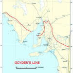
Goyder’s findings were embodied in the first schedule of the Waste Lands Alienation Act 1872, which permitted farmers to purchase land on credit only within designated agricultural areas. From east to west, ‘Goyder’s Line of Rainfall’ ran approximately from the Hundred of Pinnaroo, swung northwest to the Hundred of Commooroo and the Melrose area, southwest through Yorke Peninsula to the Hundred of Wallaroo, then northwest across Eyre Peninsula from the Hundred of Hawker to south of Darke’s Peak, and across to the Hundred of Chilundie near Thevenard.
The law was short-lived; favourable seasons in the north encouraged the government to pass Act No. 22 of 1874 repealing the 1872 Act and allowing the sale of land under credit agreement outside ‘Goyder’s Line’. A run of bad seasons in the 1880s halted the northward progression, forcing many farmers to abandon their homesteads and, more often than not, a severely eroded landscape.
Far north South Australia

Map

Monuments


By Judith Jeffery
This is a revised version of an entry first published in The Wakefield companion to South Australian history, edited by Wilfrid Prest, Kerrie Round and Carol Fort (Adelaide: Wakefield Press, 2001). Revised by the author, edited lightly and references updated. Uploaded 8 April 2014.
Cite this
Judith Jeffery, ‘Goyder’s Line’, SA History Hub, History Trust of South Australia, https://sahistoryhub.history.sa.gov.au/subjects/goyders-line/
Sources
Buxton, GL, South Australian Land Acts, 1865–1885 (Adelaide: Libraries Board of South Australia, 1966)
Kerr, Margaret Goyder, The surveyors: The story of the founding of Darwin (Adelaide: Rigby, 1971)
Meinig, DW, On the margins of the good earth: The South Australian wheat frontier, 1869–1884 (Adelaide: South Australian Government Printer, 1988; Chicago: Rand McNally for the Association of American Geographers, c. 1962)
Sheldrick, Janis M, Nature’s line: George Goyder: surveyor, environmentalist, visionary (Adelaide: Wakefield Press, 2013)
South Australian Government, Surveyor-General’s Office, Report of the Surveyor-General upon the Disposal of Public Lands of South Australia, June 16th, 1890 (Adelaide: Government Printer, 1890)
Links


Comments
5 responses to “Goyder’s Line”
In recent commentaries on Goyder’s Line I read much about ‘rainfall’,: but what is usually missing is that Goyder based his assessment on his observation of vegetation, not rainfall records.
A good point Greg, I think most of the interpretation following Goyder’s findings has focused on rainfall as that has obvious implications for agriculture, and therefore has become the way the line is most often referred to.
You Can’t spell Pinnaroo Right!!!!!!!!!!!
as a local resident of Pinnaroo i am insulted about the incorrect spelling of the town name
I have fixed the typo in this article Phillip & Andrew.